A Hasidic Spatial Turn
“One of the biggest problems we faced when creating the narrative for the POLIN Museum was how to visualize phenomena as intangible as the spirituality of Hasidism. Then I realized that almost every issue can be visualized using quantitative data on maps,” says Marcin Wodziński, the head of the Taube Department of Jewish Studies at the University of Wrocław, about his work on an atlas of Hasidism. His Historical Atlas of Hasidism, published by Princeton University Press in July, is in many respects a breakthrough.
A New History
“I consider it to be my magnum opus,” says professor Marcin Wodziński, sitting in the tastefully decorated library reading room in the newly opened home of the Jewish Studies department. Oxford University Press has just published his monograph Hasidism: Key Questions [“Chidusz” 1/2018]. Wodziński is also co-author of a collective monograph entitled Hasidism. A New History, which appeared at the end of 2017 from Princeton University Press. Of these three books recently released by the most prestigious academic publishers in the world, his large-format Historical Atlas of Hasidism is most likely, according to Wodziński, to have an enduring impact.
“It’s not that I won’t be able to write another equally important monograph,” he adds, “it’s just that I do feel that I may not come up with something that will be quite so methodologically innovative, addressed to such a diverse group of readers, and at the same time so visually striking.”
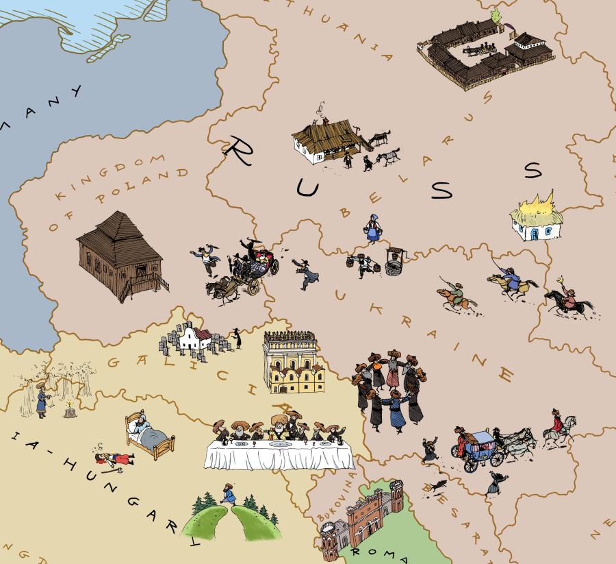
In the introduction to the Atlas, Wodziński argues that historians have studied Hasidism from a limited perspective, which is surprising considering that it was a movement of enormous cultural significance throughout Eastern Europe, and that it shaped modern thinking about Ashkenazi Jews in the eighteenth and nineteenth centuries. For years, scholars focused their attention primarily on the intellectual heritage of the Hasidic movement and tended not to incorporate non-Hasidic, non-Hebrew, and non-Yiddish primary source materials. They also focused almost exclusively on the beginnings of the movement, skirting many aspects that came to the fore as the movement expanded. And, finally, most studies dealt with the Hasidic elite and treated it as an ahistorical phenomenon whose definition remained static over time. As Wodziński points out, it was particularly easy, after World War II, to ignore territorial aspects of Hasidism as most Hasidic centers had disappeared from the face of the earth. Researchers, unfamiliar with the geography of the region, found it difficult to assign traditional names to places that fell within the borders of modern Poland or Ukraine. The Historical Atlas of Hasidism remedies this type of methodological error by firmly embedding key questions of Hasidism in a spatial turn. What is more, it examines the dynamics of the development of the entire movement, and not only changes concerning the elites.
Apart from a number of ways in which it extends the extant research on Hasidism, the Atlas has one very important advantage: it is not one long, continuous text. “In our post-Gutenberg era, readers tend to click on what interests them most, without bothering to read the entire text,” says Wodziński. “That’s why I think that the Atlas has a chance to reach an audience beyond the confines of academic circles. Maps can be viewed in any order, without even looking at the introductory text, or at least not right away. You can look at each individual map closely, and you can study each map separately.”
Clocking Dynasties
“In the past, maps were the end product: today they are just a starting point,” Wodziński explains the concept underlying the Atlas. Thanks to digital humanities tools such as GIS (Geographic Information System), it is currently possible to process mass quantities of data that even entire teams of cartographers would not have been able to handle earlier. “Even if we could have been able to upload all the data, no one researcher would have been able to foresee the results,” which are oftentimes unexpected and elusive for individual researchers.
Looking at, for example, the map that shows the geographical location of each dynasty, where each is assigned a different color, it becomes immediately apparent that individual areas of Eastern Europe were divided very clearly between different tsadikim, who basically kept out of each other’s way. This is the sort of conclusion that it would have been difficult to substantiate based only on extant research and memoirs. However, looking at areas in which numerous tsadikim resided, one notices surprising incongruities which would also have been difficult to extract even from their biographical notes, of which 1787 were analyzed for the purposes of this particular map.
The series of ten maps illustrating the dynamics of the spread of Hasidic dynasties is another example of a process that could not have been captured in a visual image based on manual data processing. Different sized circles, divided into multi-colored layers, represent successive generations of dynasties (the more generations that lived in one place, the more layers), and, additionally, individual circles are appropriately darkened in certain sections. Thus the outer borders around the circles function like a clock, informing us that, for example, a tsadik from the fourth generation of the Kobryn dynasty lived in Kobryń from ca. 1910 to ca. 1940.
Migration patterns of the tsadikim can also be seen on one of the maps, showing which dynasties were more “stationary” and which splintered in subsequent generations when the sons of tsadikim left home to set up centers in other places. One can thus study the different models of their geographic movement to gain new insights valuable for Hasidic researchers. This is probably one of the most complicated maps in the entire atlas as it incorporates a massive amount of data.
Wodziński admits that he was quite ignorant of cartography before he started working with Dr. Waldemar Spallek, head of cartography history at the University of Wrocław. “I expected the impossible, and he kept insisting that what I wanted could not be mapped,” recalls Wodziński. Working with Wodziński’s concepts and the specific solutions proposed by Spallek, they managed to create an innovative method of presenting various spatial phenomena regarding the religious movement. “Wodziński’s book demonstrates that a photo is worth a thousand words and a map millions,” wrote Moshe Idel, the leading historian of Jewish mysticism, in his endorsement.
The Miracle of Railway Tracks
“A good map immediately conveys the main message,” says Wodziński, leaning over the outline of Eastern Europe from 1874, the surface of which is covered with bubbles in various shades of red, yellow and green. This map is titled „Petitions submitted to R. Eliyahu Guttmacher” and shows what percentage of the Jewish population from different towns and villages sent requests to the tsadik, who resided in Grodzisk Wielkopolski. A single glance at the map is enough to ascertain that the closer the petitioners lived to Grodzisk, the more frequently they showered their tsadik with requests.
“But the ‘distance decay effect’ can be corrected by other spatial phenomena,” Wodziński explains. For instance, the highest number of petitions did not always occur closest to Grodzisk; sometimes the place from which the most petitions flowed was much further away, and the explanation was simple – railway lines that facilitated access passed through these more remote towns and villages. However, the route to one’s tsadik was often neither simple nor fast. According to the map, Guttmacher received petitions from London, Tiberias, Bucharest and even from the small village of Dąbki, hundreds of kilometers distant, and close to which there were dozens of other tsadikim.
To explain this, Wodziński applies the concept of the “chain miracle,” analogous to that of “chain migration,” which is a common mechanism whereby people from a given locality tend to head to the same places as their compatriots before them. Just as immigrants counted on the help of their family and friends abroad, petitioners tended to put their faith in the tsadik who had helped their family or friends. As a tsadik’s reputation for wisdom or miraculous power grew, so did the number of people undertaking the journey to his court.
Thus a simple map reveals unexpected information that would have remained virtually invisible if the data had not been visualized in a spatial dimension. This particular map was compiled from a collection of 7000 petitions addressed to Rabbi Guttmacher; nearly all of them also indicated the petitioner’s place of residence.
Prayer houses for the Chosen
After perusing maps compiled of so much data that their analysis on various levels can take hours, we move on to another map in the chapter on economic status which, at least at first glance, seems much more straightforward. Yet this particular map only appears to be less complicated. The fact that the data display is not as dense does not at all mean that it is less innovative. “It shows economic stratification in Hasidism, an aspect hitherto entirely unexplored,” explains Wodziński. From the map you can learn that individual tsadikim enjoyed the support of groups from different socio-economic backgrounds.
In Bełchatów, the most influential people in the town were Ger Hasidim; in Ratno, the Stepan Hasidim were “ordinary people.” while the Karlin-Stolin Hasidim were more well to do. The information behind these conclusions was gleaned from various sources, primarily the memorial books that Wodziński has been collecting for years. At first, he thought about writing an entire chapter in his monograph on the basis of these books (it ended up in Hasidism, Key Questions), but the material was too diverse, so Wodziński followed the advice of his “master and teacher,” Professor Moshe Rosman from Bar Ilan University, and he decided to accomplish that which at the time appeared to be impossible. The 300-page, large-format Atlas scrutinizes almost every possible aspect of Hasidism.
Not only Maps and not just the Holocaust
Wodziński’s Atlas is also unique in that the seventy-four large-format maps are accompanied by beautiful and often historically valuable illustrations and photographs. Wodziński found, for instance, a photo of the interior of the Międzybóż bet midrash (prayer house) in the Ethnography Museum in St. Petersburg, the same bet midrash in which the Ba’al Shem Tov, the putative founder of Hasidism, is said to have studied in the mid-eighteenth century. S. Ansky, a researcher of Jewish folklore, and members of his expedition took excellent photos just before the outbreak of World War I that show such fine details as the spines of books positioned deep in the background.
A photograph of the synagogue in Husiatyn taken by Jan Munzar, a Czech officer in the Austro-Hungarian army, is especially touching. A destroyed and yet still majestic building stands adrift in a sea of debris – only a handful of the houses in Husiatyn survived World War I. “It looks like a scene from the Warsaw ghetto,” observes Wodziński. A photograph of the Husiatyn synagogue also reveals the scale of destruction that Jewish life in Eastern Europe suffered as a result of the Great War. “It was a disaster that could not, it seemed, happen again – until it did. Today, the Holocaust has overshadowed that memory, but when one speaks of the end of the traditional Hasidic world in Eastern Europe, it actually ended after World War I,” reflects Wodziński.
A separate subsection and accompanying map in the Atlas are devoted to the migrations of 1914-1918, showing from where and to where the tsadikim and their courts were escaping. Most of them moved to Vienna in 1914. Many also left for Warsaw, Kiev, and Budapest, which points to fact of the urbanization of Hasidism and indicates the destruction of earlier social structures. World War I brought radical change: the tsadik from Radzymin was no longer the center of the universe for the residents of his shtetl, but, as Wodziński puts it, he now passed the tsadik of Otwock on the stairs of a Warsaw tenement as he went out for a walk or to throw away his trash.
Not many tsadikim returned to their home towns after the war. For some Hasidic dynasties, the years 1914-1918 marked a turning point and a radical decline in their development. For example, the Sadagura dynasty, once dominant, never regained its popularity after it relocated to Vienna. Beginning in the interwar period, its supporters declined in numbers and today it is a marginal group.
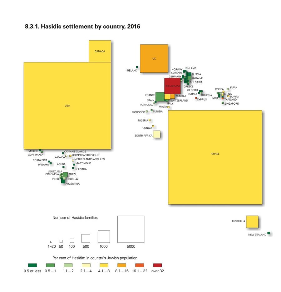
Hasidic settlement by coutry, 2016. Map has been based on extensive database of 129,000 Hasidic households created for the prurpose of this research
Telephone Book History
The two final chapters of the Atlas are dedicated to contemporary history. The maps in this section show the largest Hasidic centers in the world today. Different sized circles represent Dorling cartograms: the bigger the circle, the more Hasidim living in a given place. Israel basically disappears from view under a big bubble, while Poland is clearly visible, with only two small circles indicating the Chabad-Lubavitch families living in Krakow and Warsaw, and a third for a family of the Alexander dynasty in Łódź.
To show where and in what percentage Hasidim live today, Wodziński used data for 130,000 families, which accounts for, he estimates, ninety percent of the members of this movement currently living in the world. Although, of course, there is no universal census available as such for any country, almost every major Hasidic group creates its own quasi-census for its own needs. “Each of them has its own telephone directory with addresses, which basically functions like a membership list,” explains Wodziński.
The phone book is important because it documents membership in a given group. “If someone wants to send their child to a Boyan Hasidic school (the largest branch of the Sadagura dynasty today), and they are not included in the phone book, the child will most likely not be accepted. The parents will not be anash.” Anash is an abbreviation for anshei shlomeinu – our people.
Each of these phonebooks is also a list of the Hasidim belonging to a given dynasty. Thanks to this, it was possible to construct maps that showed not only the size of Hasidic centers in the world, but also their internal structure, and which dynasties dominate: the largest Hasidic group at present is Satmar (26,000 families), followed by Chabad-Lubavitch, and Ger.
Wodziński also analyzed how the structure of Hasidic centers has changed over the last twenty years. A glance at the map of the distribution of members of the Bobova dynasty in 1996 and 2016 indicates that the number of individual centers has not changed. At the same time, knowing that at the beginning of the 21st century, due to a leadership conflict, some of the Hasidim of Bobova split off to form the Bobov-45 group, one can discern something surprising. “If we realize that a third of the Bobov Hasidim left, the fact that the bubble is the same size in both 1996 and 2016 indicates a demographic increase of 50 percent,” the author explains.
A Tish Atlas
“If anyone wants to attend a Hasidic tish, I can show you where the tsadikim live. It doubles as a tourist map,” jokes Wodziński. He does not, however, specify what each tsadik specializes in, so readers have to work out on their own to which tsadik they need to go with their specific problem.
Tourists traveling in exotic places where there very few Jews often come across Hasidim from the Chabad-Lubavitch group. Two maps showing the distribution of Chabad centers in 1999 and 2016 show an interesting trend. Chabad is growing in countries such as India, China, Vietnam, Thailand, and Nigeria, i.e., in places where there are no strongly rooted Jewish centers. In Argentina, in turn, there is a large Jewish community but Chabad centers are scarce. “Chabad is interested in the Jewish periphery,” explains Wodziński.
A Hasidic motif can be found even in Wrocław – a center of Jewish enlightenment and reforms – although unfortunately its traces are still waiting to be discovered. For a short time, for about a year after the end of the second world war, the function of dayan, deputy rabbi, was performed by the rebbe of Przeworsk, whose successor currently lives in Antwerp, one of the largest Hasidic centers in Europe.
One needs to mention the riveting photos used in the Atlas of contemporary members of the community from various places in the world, as well as those on pilgrimages to the tombs of tsadikim in Poland and Ukraine. These images were taken by Agnieszka Traczewska, the author of the photo album Powroty (Returns) that was released this year, depicting a glimpse of the magical and inaccessible (especially for women) world of Hasidic rituals and everyday life.
An Atlas for All
Asked whether Hasidim will be interested in the Atlas, Wodziński replies that he does not see why they wouldn’t be. Although members of the Hasidic community are usually reluctant to look at academic, non-religious publications, they may be willing to make an exception as the Atlas describes various facets within the movement so astutely, and also reveals certain aspects hitherto unknown even to Hasidim themselves. “There is nothing that could be controversial for Hasidim. There is no nudity or blood-letting. The book treats Hasidism with great respect, so I hope that the Atlas will suit the religious sensitivity of a Hasidic reader,” says Wodziński.
At the same time, he points out that there are materials that may be especially important for Hasidim, for non-academic reasons. Wodziński, for example, managed to identify a character in a painting, which had been regarded as the portrait of an anonymous Jew, located in the National Museum in Kielce. It turned out that it was the portrait of a tsadik from Chęciny. This is a kind of discovery for Hasidim, as there are only a few extant photos of very poor quality of Chaim Sternfeld-Horowitz, and the portrait reproduced in the Atlas might even achieve iconic status.
However, the Atlas was not created with Hasidim or even Jews identifying with their Ashkenazi origin in mind. Wodziński counts on the work reaching beyond people interested in the history of their ancestors or Jewish studies specialists. The innovative approach to the development and structure of the religious movement should be of interest to researchers of religion, and the way of constructing maps should engage geographers and cartographers. Above all, he reasons, maps are much easier to read than text, thanks to which almost everyone who wants to know the history of Jews in Europe will be able to use the Atlas.
Translation from Polish: dr Barbara Pendzich